
Weekly newsletter: May 12, 2026
Hi everyone!
Happy belated Mother’s Day!
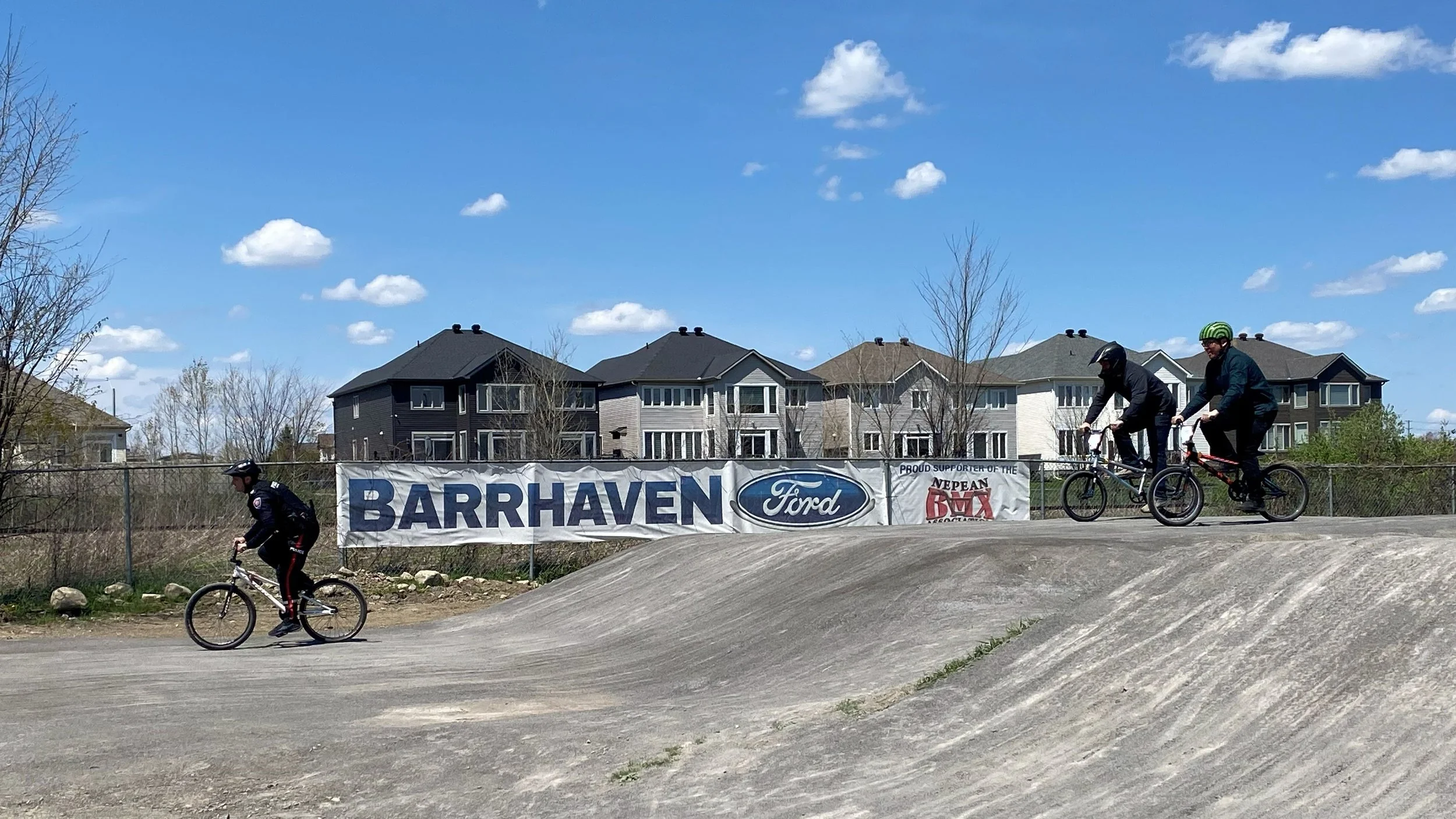
The photo above is from Nepean BMX’s open house on Saturday, where I got to ride around the track on a BMX bike for the first time. They’re very different from regular bikes. Councillor Hill, a police officer, and several young children beat me handily in our race. As my physical fitness peaked in my 20s, my legs were on fire afterwards.
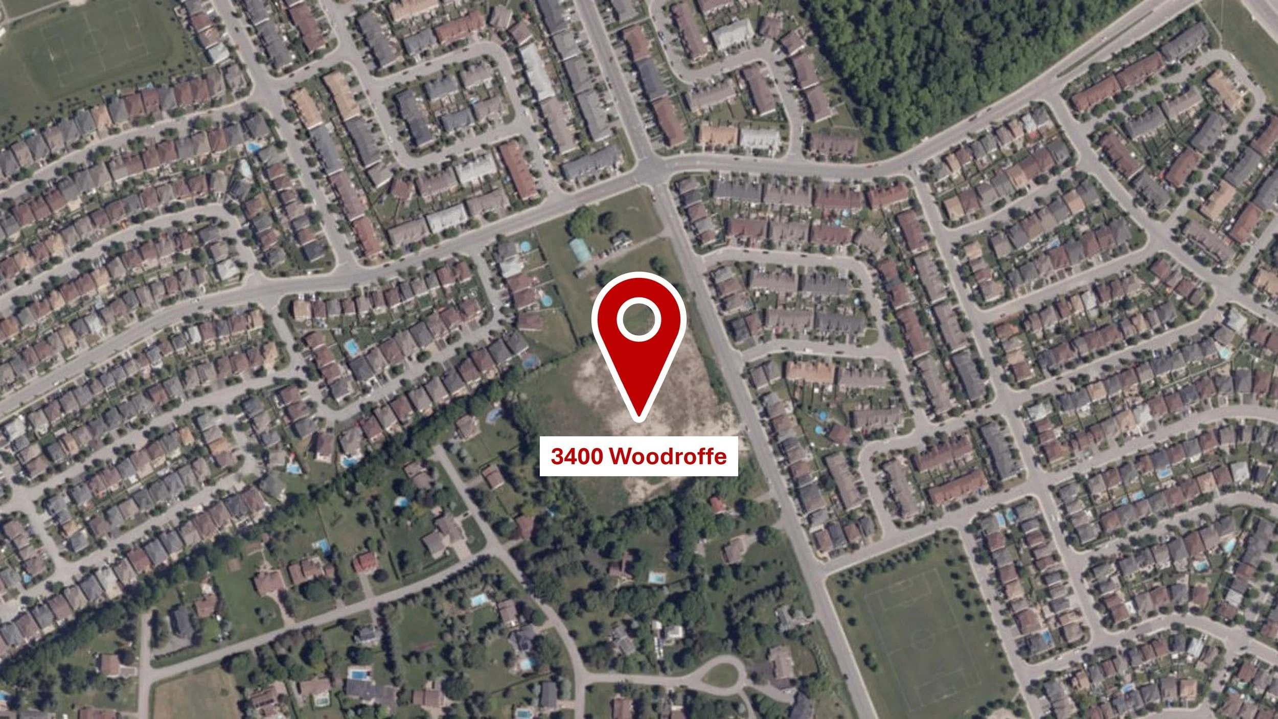
3400 Woodroffe development application
Notes from the public information meeting of April 29.
Back in January, developer DCR Phoenix submitted a development application↗ for the vacant parcel at 3400 Woodroffe Avenue, located south of Paul Métivier.
Given public interest in the file, I hosted a public meeting two weeks ago to share the information I have so far about the development, as well as relevant background and limitations of the planning process. Thank you to the approximately 25 residents who came out on a rainy Wednesday evening!
The presentation was divided into five sections: site context, legislative context, the development application, managing expectations, and what’s next. Residents also asked questions throughout and after the presentation. Both are summarised below.
Site context – The previous owner of 3400 Woodroffe received approval in 2005 for a 30-lot (I incorrectly said 26 lots at the meeting) bungalow subdivision. That approval was renewed every few years, but development never proceeded, and the approval lapsed in 2025. Developer DCR Phoenix purchased the parcel some time in 2024 or 2025 and submitted the current development application in January 2026.
Legislative context – Although municipalities have local zoning by-laws and official plans, the ultimate legislative authority for planning and development is the provincial government through the Planning Act.
For example, after the City of Ottawa adopted its current Official Plan in 2021, the provincial government made several amendments, mostly increasing density minimums, before giving its ultimate approval.
Eleven amendments to the Planning Act made by the provincial government since 2022 have reduced planning application requirements, tightened timelines, changed appeal rights, and reduced the role of municipal councils with the goal of improving residential building in Ontario. Generally, a municipal council’s role is more or less administrative, such as ensuring documentation is submitted and signed by qualified personnel.
For 3400 Woodroffe, the only Council decision point is rezoning, which is land use and density only. That density is mostly guided by two factors, that Woodroffe is designated as a minor corridor in the Official Plan, and that the parcel is within a 600-metre radius from a transit station (the radius was one of the amendments to the Planning Act).
Woodroffe’s minor corridor designation allows for developments of up to nine storeys (the City approved six storeys, but the province revised it up), while the transit station radius also increases density minimums. The legislation is indifferent towards actual service levels at the station. The lower of the two is the transit station radius density, which the developer is proposing to build to.
As it meets those legislated requirements, the City rejecting the application would most likely result in a successful appeal by the developer to the Ontario Land Tribunal. Previously, neighbouring properties also had the right to appeal a planning decision, but those rights were removed by one of the province’s amendments. The right to appeal is now limited to the developer, landowner, public utilities, and the provincial government.
Following rezoning, the site plan process begins, which deals with the actual built form of the development. Site plan used to be a Council decision point, where requests like local infrastructure improvements could have been added as a condition of the approval. Site plan authority was removed from Council and delegated to City staff in 2022, whose decisions are strictly administrative.
The development application – The developer is seeking to rezone the parcel to permit higher residential density, from the current zoning, R1VV, which is similar to Hearts Desire, to R4Z, which is similar to Bonita Private and the new construction at Fallowfield/Cedarview.
The proposed development includes 160 units: 108 stacked townhouses, 32 back-to-back townhouses, and 20 traditional townhouses, with 207 resident and 15 visitor parking spaces.
A 10-metre landscape buffer, a condition of the previous subdivision approval, was voluntarily retained by the developer as a consideration for Hearts Desire. All trees along the property line will also be retained, other than a few trees to be removed for fencing. According to my most recent information, all units will be for purchase.
Initially, the rezoning application was scheduled for the May 6 planning committee meeting, but it was postponed after staff added requirements for a hydrogeology study for more information about potential impact to well and septic systems in Hearts Desire, as well as concerns about the site’s single access point. No new date has been set.
Managing expectations – Although the hydrogeology study and site access points were additions to the rezoning application, both are solvable. The solution for site access may be a second access or a widened access, the latter of which is more likely, given its lower impact on the site plan.
What triggered the hydrogeology study was the stormwater plan showing runoff from the property going through adjacent private properties, which is not permitted and can have an adverse impact on well and septic systems in Hearts Desire. The study’s results may determine further requirements, and staff believe the overall process can take a few months.
In terms of community benefit, Council used to be able to include things like local infrastructure improvements as conditions of a site plan approval, but that is no longer possible. My request for signals or a roundabout for the Woodroffe/Cresthaven-Paul Métivier intersection must be agreed to by the developer.
I’d rather try working towards a good outcome within the legislative context noted earlier than start a performative fight that I know is not winnable. The current application will likely be the application with the lowest density on this lot.
What’s next – With the new hydrogeology study and site access point request, the planning committee date for the application has been postponed, with no new date set. As of last week, the developer has not responded to the new requests yet.
Further updates, including a new committee date, will be communicated via the newsletter.
Questions, feedback, and answers – Residents also asked questions throughout and after the presentation, which are summarised alphabetically below.
Clarification on rezoning, as it amends the current Zoning By-law, but the City just passed a new Zoning By-law (yet to be enacted) – Approved amendments will automatically be carried over and apply to the new Zoning By-law.
Density transition requirements – Transition requirements apply between low rise and high rise developments only. At under four storeys, this development is considered low rise. Grading is unfortunately not a consideration.
Impacts of secondary site access to the site plan – A secondary access will impact the site plan, but I learned after the meeting that widening the access is an acceptable solution.
Rentals or owned units – Current information is the units will be for purchase. It’s possible some future owners may choose to rent out their units.
Roadway improvements – Sidewalk and curb will be added to the lot frontage as part of the development. An all-way stop is being considered for the site access, as it forms a four-way intersection with Stoneleigh. Parking regulations will also be adjusted at the four-way intersection, while more may be added reactively.
Schools – School boards review their attendance boundaries periodically and make necessary adjustments to better balance attendance across their schools (or request funding for new schools, if required). The most recent examples are the adjustments to the boundaries of St. Joseph and St. Mother Teresa in response to the new subdivisions in the southern Barrhaven.
Stormwater impacts to Marjan Crescent – The proposed development includes an internal stormwater system with catch basins connected to the main under Woodroffe. Stormwater runoff should not travel via adjacent private properties. I’ve asked staff for more information about the arrows in the plan that show runoff onto adjacent properties on Marjan. The hydrogeology study looks at well and septic impacts only.
Street parking – The development will increase street parking usage, expected to mostly impact the west side of Woodroffe, which will be converted from an unpaved shoulder to a sidewalk and curb. The development includes 207 resident and 15 visitor parking spaces, so any impact is more likely to be from visitors than residents. Parking regulations may be adjusted accordingly—proactively at the Woodroffe/Stoneleigh intersection (sightlines), reactively elsewhere.
Terms of reference for the hydrogeology study – Posted online↗.
Traffic infrastructure improvements to Woodroffe/Cresthaven-Paul Métivier – Previously, those requests could be added as conditions of site plan approval, but that is no longer allowed. The developer must agree to such a request. Separate from the development application, traffic counts of the intersection have been completed annually, which returns a warrant score of about 85 per cent (100 per cent is needed for signalisation or roundabout).
Woodroffe minor corridor designation – This was done as part of the Official Plan process before 2021. The corridor designation could be amended (which I’m willing to move) whenever the plan is refreshed, but note the provincial government has final approval on official plans across Ontario.
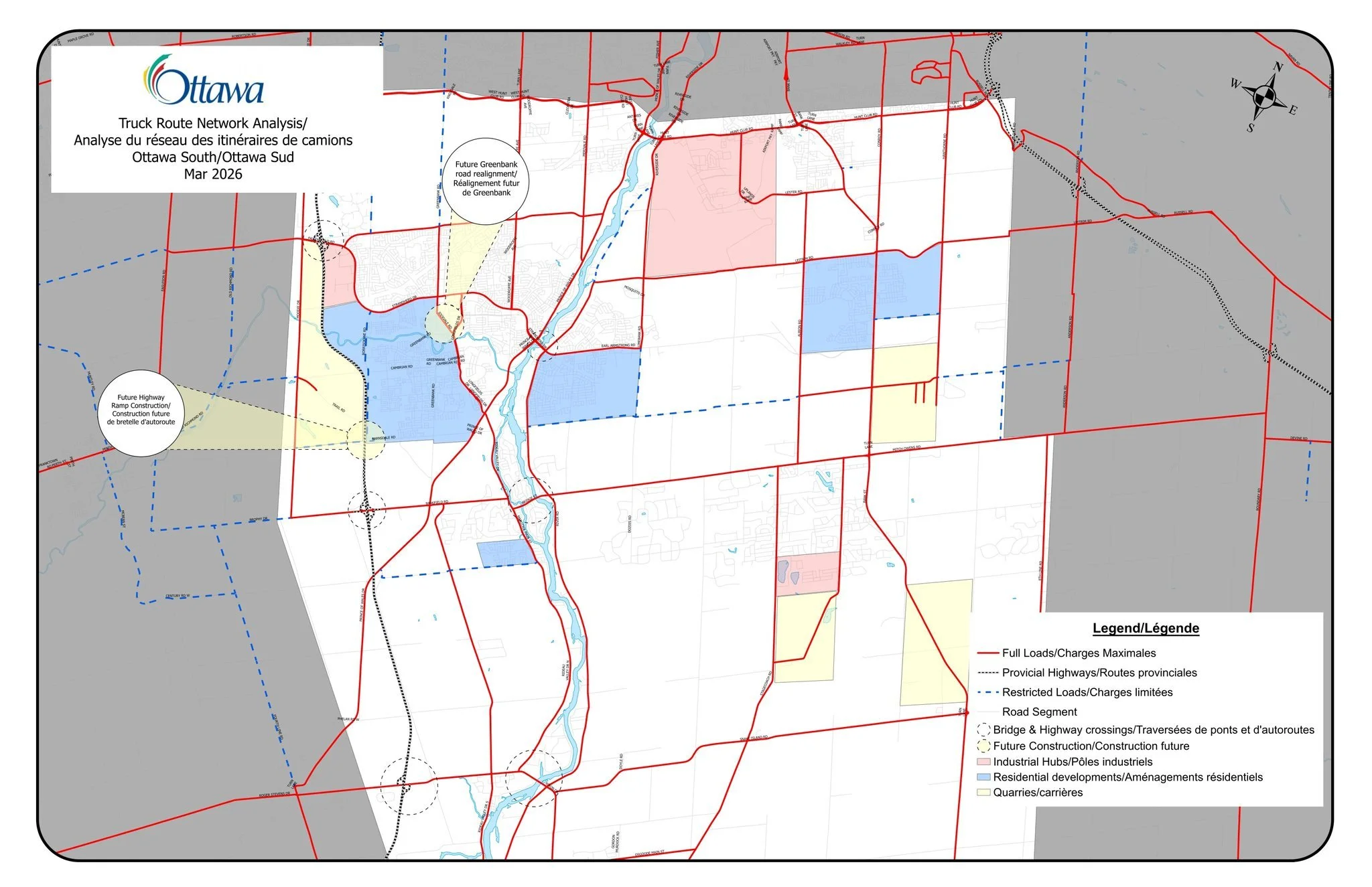
South end truck route study
In response to advocacy in Manotick to divert truck traffic from Bridge Street to Vimy Bridge.
City staff are starting a comprehensive review of the truck route network south of Hunt Club in response to public feedback about the increase in heavy truck traffic, particularly crossing the Rideau River at Hunt Club, Vimy Bridge, Manotick, and Kars.
Truck routes are roads designated to permit through truck traffic as they cross the City to service businesses, industry, and more. Trucks should remain on those roads unless their destination is off a truck route (eg. residential moving truck).
In urban and suburban areas, all arterial roads are truck routes, such as Strandherd, Woodroffe (north of Strandherd), and Prince of Wales. In rural areas, including through the Greenbelt, not all roadways are part of the truck route network, while some may have restrictions based on weight and time of year.
The primary trigger for the review is Manotick, as residents there are advocating for the truck route on Bridge Street to be shifted up to the Vimy Bridge. Bridge Street is an important river crossing for the rural economy, connecting rural industry and businesses, like agriculture and quarries, with customers and other businesses.
Indiscriminately exporting a problem to another community is not a solution.
Shifting truck traffic up to the Vimy Bridge would not only be disruptive to our community, but it would negatively impact the rural economy by increasing costs and reducing efficiency by unnecessarily adding about 10 kilometres to cross the Rideau River one way.
Through the review, discussions and decision-making will be based on data and consideration for downstream effects on the rest of the network, other communities, and the rural economy.
Safety, efficiency, and community impact of the existing truck route network will be reviewed, but staff will also explore possibilities for changes and additions to the network, ranging from changing a road’s designation to new infrastructure.
An Engage Ottawa page↗ has been set up for the review, which includes a map of the current truck network, staff contact information, and a survey that closes on May 19. Future stages of the study will include additional surveys and public meetings.
Aside from pushing back on Manotick truck traffic being pushed into Barrhaven, I will also share feedback about truck route enforcement, mostly through feedback I have received from residents along Crestway and Paul Métivier about commercial truck traffic using those corridors as short cuts.
Bite-sized updates
Sorted alphabetically. New/updated items marked with asterisk (*).
Beatrice/Queensbury (bus stop 3345) shelter – The tender for bus shelter installation across the city will be posted this week. Staff anticipate this shelter’s installation in July.
*Development application, 3400 Woodroffe↗ – Thank you to the residents who attended last week’s public information meeting. Minutes and supplementary information have been shared above.
Earl Mulligan Drive – Traffic calming construction begins this week, with an anticipated early-July completion. See Ottawa.ca/EarlMulliganDrive↗ for more information, including a project overview.
Fallowfield Via Rail Station – Construction will happen 10:00 pm to 10:00 am nightly from May 11 to June 30 (excluding Fridays and weekends, unless delayed by weather during the week) for a partial rebuild of the train station’s island platform. No impacts to the OC Transpo station are expected.
Household hazardous waste – This year’s drop-off depots near Barrhaven are noted below. See Ottawa.ca/HHW↗ for instructions and depots scheduled for other dates and further away from Barrhaven. Many items, like light bulbs, spent batteries, old tires, paint, electronics, and more, can also be dropped off at retailers and other locations↗ throughout the year.
June 28, 8:00 am to 4:00 pm – Trail Road Landfill, 4475 Trail Road↗
October 17, 8:00 am to 4:00 pm – Strandherd snow dump, 4061 Strandherd Drive↗ (enter via Dealership Drive)
*Longfields/Via Verona sidewalk – Construction will begin in the coming weeks to fill a missing link in the sidewalk on the west side of Longfields between Via Verona and Via Chianti. Originally, this was to be done with the adjacent parcel’s development, but with a horizon of seven to 10 years, an arrangement was made with the developer to install an interim sidewalk made of asphalt. The interim sidewalk will be winter maintained. Thank you to the resident and their daughter who raised this at my town hall last autumn!
*NCC Bike Days – The National Capital Commission’s weekend and holiday closures↗ of the Queen Elizabeth Driveway have resumed. Like previous years, the driveway will be closed to motorised traffic between Fifth and Somerset weekends and holidays from 8:00 am to 8:00 pm until Thanksgiving. Similar closures also affect the Kichi Zībī Mīkan and the Sir George-Étienne Cartier Parkway.
Police office hours – South District officers are hosting drop-in office hours as part of their community outreach. Their next day is May 14, 10:00 am to 2:00 pm, upstairs by the food court at the Walter Baker Sports Centre. No registration needed.
Potholes – Please report potholes to Ottawa.ca/311↗. The requirement to provide contact information for pothole reporting has been made optional starting this year.
*Race Weekend – Several roads downtown, along the Ottawa River, and along the Rideau Canal down to Mooney’s Bay will be closed at various times next weekend (May 23 to 24) for the 2026 Ottawa Race Weekend. See RunOttawa.ca↗ for a list of closures and an interactive map.
Riverside/Bank – Ongoing Bank Street construction will affect residents whose commute includes the Riverside/Bank intersection, including lane closures and roadway shifts now until August 31. See Ottawa.ca↗ for more information.
Road cuts remediation – The road cuts near Cresthaven/Versilia (winter watermain break) and at Woodroffe/Deerfox (private water/sewer connection) will be properly remediated by mid-June, as hot asphalt becomes available.
*School transportation opt-out – Parents with children in the two English school boards who are eligible for school transportation but wish to opt out for next school year must do so by June 1 at OttawaSchoolBus.ca↗. No information was provided about the French school boards.
*Strandherd bus lane resurfacing – The bus lanes on Strandherd between Prince of Wales and west of Cresthaven will be resurfaced from May 20 to 26. Overnight work, 10:00 pm to 7:00 am, will be required for three days within that stretch. Notices will be delivered to nearby homes, while the property manager at the Prince of Wales Manor and Stonefield condominiums have been notified.
Summer jobs with the City – Summer job postings in parks and recreation are now live at Ottawa.ca/jobs↗. Please note some positions are restricted to post-secondary students, while others are open to all students.
Summer recreation registration – Summer recreation programming is now available for browsing at Register.Ottawa.ca↗. Aquatics registration opens Tuesday, May 12 (tonight) at 9:00 pm, while registration for all other activities opens Thursday, May 14 at 9:00 pm.
Walter Baker Sports Centre – The swimming pools will be closed for structural and deck repair works from May 11 (tomorrow) to June 28. Annual maintenance will also be completed during the closure.
Enjoy your week ahead!
-Wilson