
Weekly newsletter: November 21, 2023

Hello, and welcome to the almost-end of November!
It was so great to see so many of you lined up along Beatrice and Strandherd on Sunday for the Santa Claus Parade!
As the community gears up for the holiday season, keep an eye out for craft markets and consider supporting small local vendors when shopping for people in your life.
If able, please also consider making a donation to the Barrhaven Food Cupboard at their bins after the checkout at grocery stores across Barrhaven. It’s often more dangerous to be in poverty or food insecure in the suburbs, because much of it is invisible.
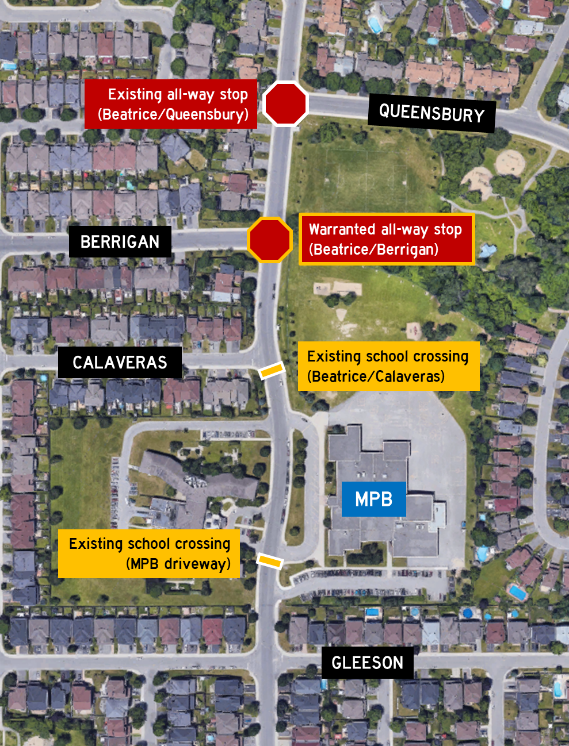
Beatrice/Berrigan
Earlier in the autumn, a resident requested an all-way stop at the intersection of Beatrice and Berrigan through 3-1-1.
As with all traffic control requests (including stop signs, traffic signals, pedestrian crossovers), City staff had to complete an assessment of the intersection to determine if an all-way stop was warranted at the intersection, which shows Beatrice/Berrigan does meet the warrants for an all-way stop.
Although implementing a new all-way stop at Beatrice/Berrigan will improve safety at that intersection, my worry is it will result in an overall net decrease in safety along the stretch of Beatrice Drive in front of the school.
If implemented, the Beatrice/Berrigan all-way stop would be just 90 metres south of the existing all-way stop at Beatrice/Queensbury and just 100 metres north of the school crossing at Calaveras (which itself is 130 metres north of the other school crossing).
This means there will be four traffic controls in about 325 metres, although it will be just the two all-way stops at Queensbury and at Berrigan when the school crossings are inactive.
The overall net decrease would be the result of motorists behaving out of impatience and to make up for perceived lost time, including speeding between each traffic control, speeding through the rest of their drive, and not complying with the controls, which can jeopardise the safety of pedestrians, motorists, cyclists, and crossing guards.
An obvious solution would be police enforcement, but I hope you can appreciate we can’t expect officers to be posted at the location daily and for extended periods of time.
I made some alternate suggestions to staff, including building a roundabout at Beatrice/Berrigan instead, but roundabouts require a higher warrant score due to their cost and disruption in implementation.
Basically, the all-way stop is the only option, and as an assessment shows it is warranted, the City is now obligated to install the traffic control. However, as the construction season has ended, implementation could not happen until mid-April, which buys me a few months to really get some meaningful feedback from area stakeholders, which includes the parent council, school administration, the long-term care home, and residents.
I have two options: do nothing and allow the all-way stop installation to proceed in the spring, or submit a Councillor’s report to strike the assessment results to leave Beatrice/Berrigan as-is (which requires support from my Council colleagues).
This is where I would like your feedback, given the above. Although my personal view is adding the all-way stop will be detrimental to overall safety, I’m putting that opinion aside to listen (well, read) what you might have to say.

Community safety data portal (beta)
Recently, the Ottawa Police Service launched the beta version of their community safety data portal, which aims to provide residents with an overview of police activity in the community.
Within the portal are an overall crime map, an overdose call dashboard, and hate-motivated crime statistics.
The crime map provides residents with a visual overview of police activity across the city generally as a result of reported crime. Residents may set different filters to see different datasets, including by date (back to 1 January 2023), by ward, and by type of offence.
Each offence bubble in the map can be expanded with some high level information including the date and time of the offence, type of offence, and a link to report a tip.
The overdose call dashboard provides information about the number of overdose calls the OPS have responded to over the last five years. Like the crime map, residents may filter information by date, ward, and neighbourhood.
Lastly, a table with statistics about hate-motivated crimes reported to police is also available, with information dating back to 2015. The table breaks down information into date and time, type of hate-motivated crime, and the type of offence.
The top of the portal also provides several links to other datasets the OPS maintain, including ward-by-ward crime trends, a motor vehicle theft overview, and other general open data information.
Interested residents are encouraged to take some time to explore the tools and share feedback about the new portal with the Ottawa Police Service through a feedback survey at the bottom of the portal.
Chief Stubbs and OPS leadership are hopeful the portal improves community engagement with the police, especially as they continue to make major investments in our community and across the city (not the least of which is the new police station).
Transit virtual town hall
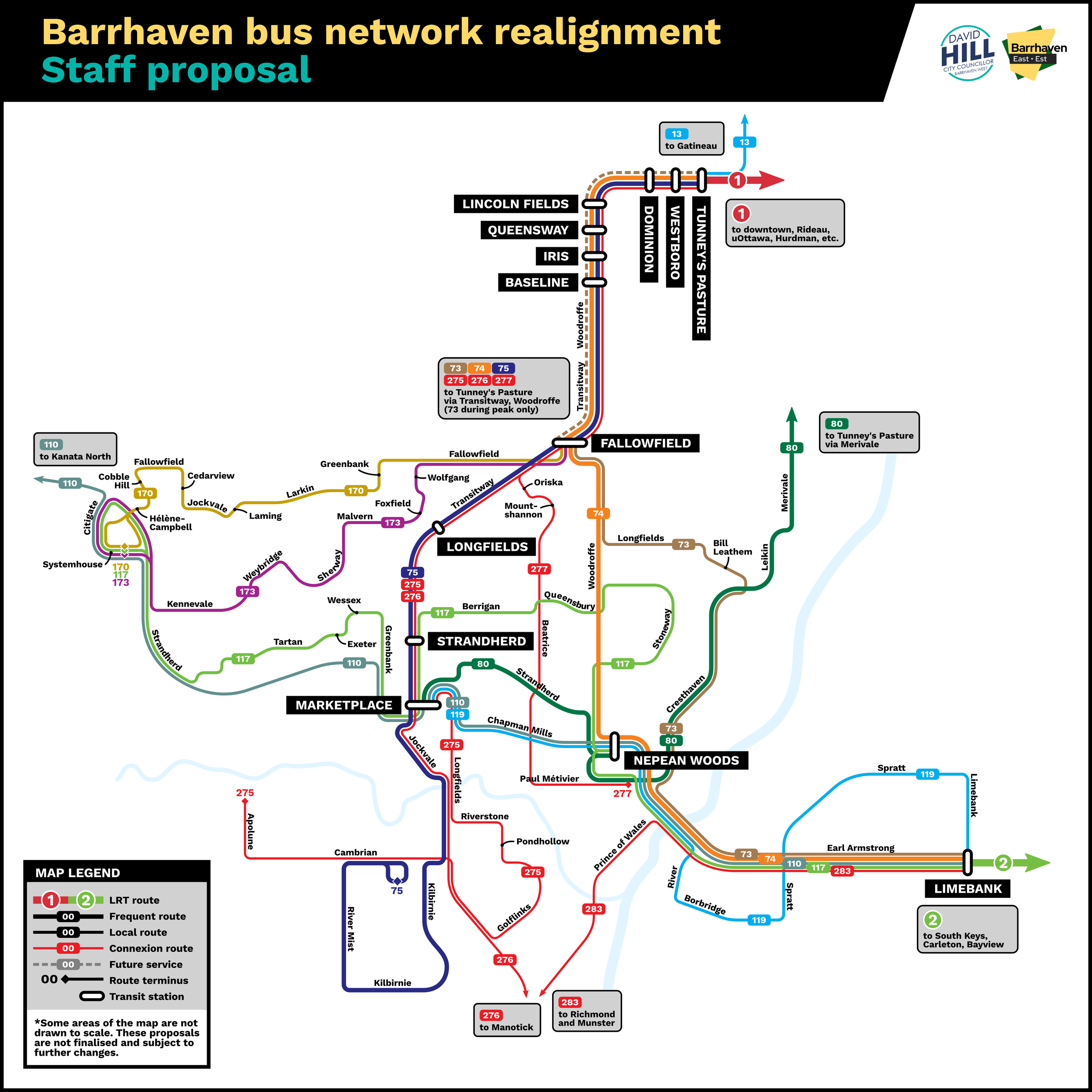
As many residents may know by now, OC Transpo is undertaking a major review of its bus routes and proposing several major changes to realign the network with our city’s new commuting reality and to ensure transit can succeed in this new reality.
In Barrhaven, the staff proposal reorients several services from commuter services to be more community-focused, including improved connections across Barrhaven and new connections to O-Train Line 2 which is scheduled to enter service in 2024 (no bus route changes will happen until after that line opens).
Line 2 starts in Riverside South, and offers connections to South Keys, Carleton University, Dow’s Lake/Little Italy, and downtown via Bayview Station and Line 1. A connection to the airport is also available at South Keys via future Line 4. The end-to-end travel time from Limebank to Bayview Station is projected to be just about 30 minutes.
Over the last two newsletter issues, I have been sharing information about the route review/realignment. The November 7 newsletter provided an overview about the process and why it was necessary, while the November 14 newsletter had more information about individual routes proposed for Barrhaven East.
To OC Transpo’s credit, they generally been accommodating and receptive to change requests and suggestions from Councillor Hill and me. The requests we have made so far include:
Rerouting route 73 via Longfields and Mountshannon (east) to Oriska – accepted
Extending the 173 along the Transitway from Fallowfield to Marketplace to connect Old Barrhaven with the shopping/employment area – accepted
Removing buses from the Strandherd-Systemhouse left turn, instead routing them via Cobble Hill and Maravista – accepted
Reimplementing portions of the 271 and 273 – not yet accepted
Councillor Hill and I would like to invite residents to a transit virtual town hall we are hosting on Monday, November 27 at 6:30 pm.
This is an opportunity for us to present the changes as amended so far, as well as to gather additional community feedback to guide further discussions and planning with staff. OC Transpo staff will be on hand as well. There is no registration required.
Until then, enjoy your week!